Lynn Harbor is our most recent location for prototype deployment. Our location is close to the shore but exposed to serious open ocean wave action from the harbor mouth at Southwest. This was also our first test implementation of a linked-network layout with multiple units. We deployed three Spiral Net Prototypes connected to each other and secured in place with mooring buoys and anchors.
Compared to more sheltered urban harbors such as nearby Boston, Lynn sees high wave energy especially with certain weather patterns which limits recreational and industrial uses of the harbor and subjects the shoreline to aggressive wave damage and erosion. The goal of this prototype deployment was to monitor how well the three biomass units and the linked-network scheme could withstand winter conditions with high wave energy, wind exposure, tidal action, and even ice formation. The network was launched in October 2024, without the inclusion of any living plants in these mats; instead, we focused on unit design, network connections, and buoyancy variables.
After receiving permission from the Harbormaster and the Conservation Commissioner, we worked with local community members to deploy the prototypes and anchoring system from a launch boat. Lynn has been an ideal site because of the welcoming community, encouraging us to try our project and providing site access and launch assistance. We have developed connections with several key community leaders, some with decades of boating industry experience in Lynn.


Site Description
The three-unit network is located 1000 feet from the mouth of the Saugus River and 200 feet seaward of the deteriorating wooden seawall along the Lynn waterfront. The tidal range is 10 feet, so the water depth in this location ranges from about 10 to 20 feet. Waves, wind, and currents are moderate to severe depending on wind direction.
Lynn periodically experiences high wave energy events, so the 5000-foot-long wooden seawall was likely initially built to protect from erosion. The intertidal marsh land that was enclosed behind the seawall was infilled by 1938 as part of the creation of the “Heavy Industrial District” (1949 USGS map). At first it was home to the Lynn Gas and Electric Company, and over the years held a drive-in theater, a coal tar disposal site, garbage dump, parking lots, clubs, big box stores, and a flea market. The seawall along the waterfront now has significantly decayed, with massive breached openings in the wood, collapsing sections, and missing pilings. As of 2025, a mixed-use development with 850 apartments is under construction on the former garbage dump section of the infilled district, within the FEMA AE flood zone, just 5-7 feet above historic high tide levels.
The flats between the Nahant isthmus and the Lynn coastline were once part of a massive marsh system that sprawled up what colonists called the Saugus and Chelsea Rivers. Dredging for coal and oil delivery and landmaking on tidal flats have made the harbor what it is today. Much of today’s Lynn harbor is a sandy and silty shoal, with one active federal shipping channel and several defunct channels.
Lynn Harbor is an ideal location to study coastal dynamics, sediment transport, wave-current interaction, and vegetation interaction. It also is the ideal candidate for a large-scale ecological restoration or nature-based infrastructure project to protect the shore, since further erosion risks leeching decades of buried industrial waste into the ocean.
Prototypes
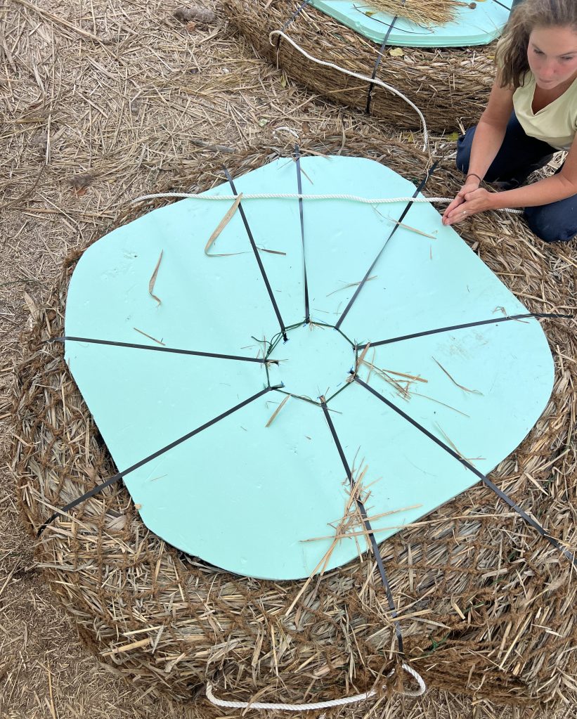
We deployed three prototypes in Lynn, with the standard Spiral Net style of biomass-based substrate. The thickness of marine foam varies, as we wanted to test longer-term effects of buoyancy and biomass saturation on unit draft. Foam sheets of 1 inch, 1.5 inch, and 2 inch thicknesses were applied to the three prototypes, lashed to their bottoms.
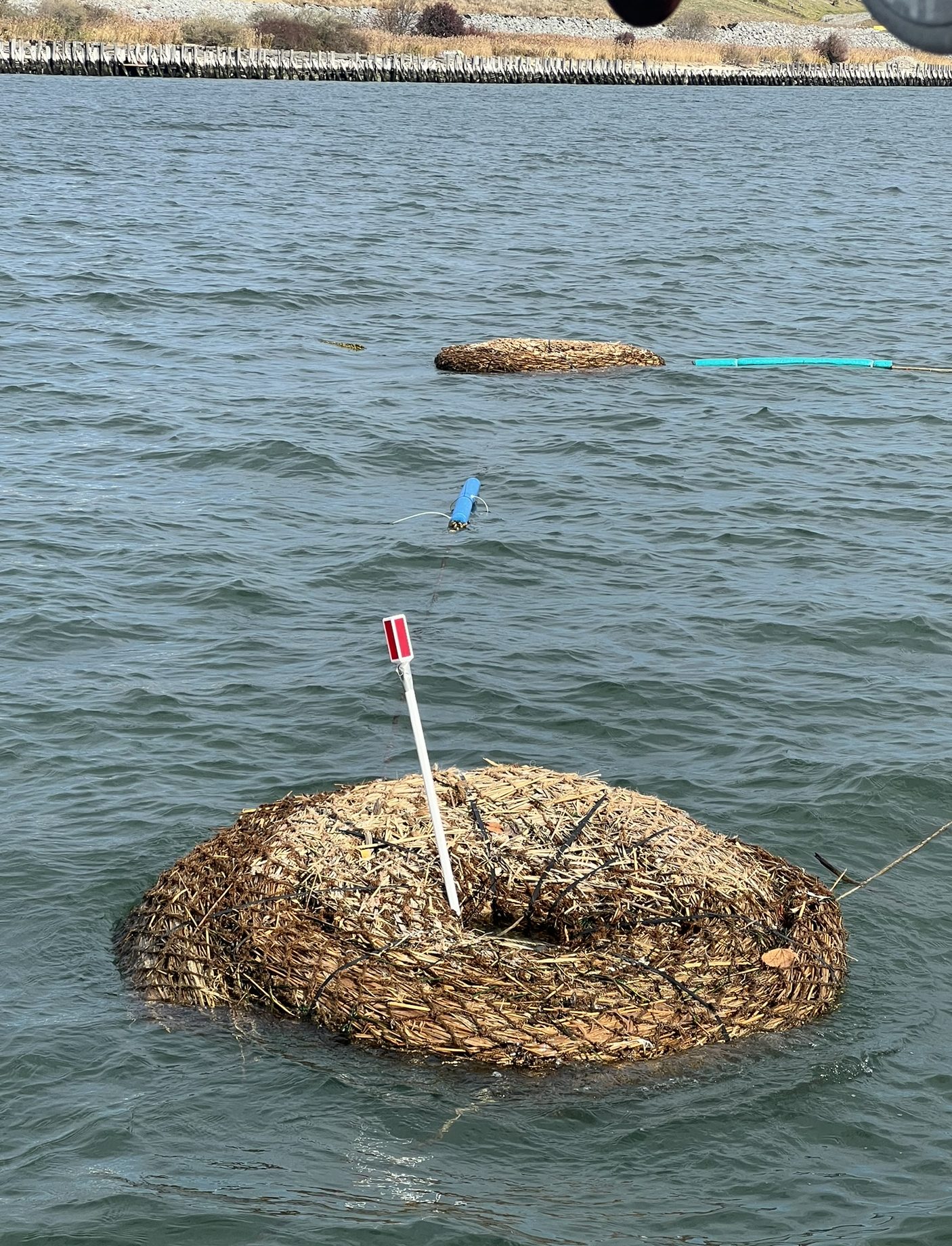
These prototypes have a hole in the middle of the spiral, similar to a donut shape. This opening allowed us to create the units with late-season Phragmites that are stiffer and harder to roll tightly. These prototypes did not contain any Spartina plants; since the launch date was so late in the season (October 11th, 2025), the live marsh grass would likely not survive the winter. The three units were linked to one another with the nylon ropes of the tension yoke tied together, and were secured in place with three anchor points: standard mooring rigs with buoys and anchors.

Monitoring
We conducted monthly monitoring throughout the winter to see how the biomass-based mats held up against winter conditions. Visual observations were initially taken from a boat, and subsequently with binoculars from shore for the coldest months. A thorough kayak investigation will allow us to inspect all components for wear and tear when the Spring arrives.
As of this writing (March 2025) the units have remained stable, afloat, and connected. There are signs of birds using the structures and some algae has grown along the ropes. The coconut fiber, straps, and foam seem to be intact. If we have any winter Nor’Easters, that will provide valuable information on the durability of these prototypes. Check back here for updates!


Successes & Failures
Successes:
- Lynn was the first location where we deployed multiple units in a network arrangement, connected directly to each other.
- The real-world forces on the materials of these prototypes are—thus far—below the material’s breakage thresholds. The foam, for example, is susceptible to cracking, but our approach to attachment minimizes this risk by effectively reinforcing it with the strength of the biomass.
Failures:
- Deploying massive prototypes and heavy mooring weights without a GPS device was tricky, requiring re-adjustments that added significant time.
- Maneuvering the floating elements, connections, and mooring points from the boat was difficult. It was a “crash course” in managing wind drift forces, rope resistance forces, and the boat’s movement forces.
